NHC HURDAT2 · SPC Tornado Database
Hurricanes and Tornadoes That Hit Canton, GA
Every tropical system within 75 miles since 1851 and every tornado within 25 miles since 1950.
Data: NOAA NHC HURDAT2 and NOAA SPC tornado and hail reports, through 2025 · Updated
14 tropical systems have passed within 75 miles of Canton, Georgia since 1851, 0 of them at hurricane strength; the most recent was Helene in 2024. Since 1950, 104 tornadoes have touched down within 25 miles, 12 of them rated EF3 or stronger.
- Hurricanes
- 0
- Tropical storms
- 14
- Tornadoes
- 104
- EF3 or stronger
- 12
within 75 mi, since 1851
below hurricane strength
within 25 mi, since 1950
29 deaths in all
What the records show for Canton
None of the 14 tropical systems was at hurricane strength as it passed Canton; the strongest was Zeta in 2020, a tropical storm with 58 mph winds when its centre passed 29 miles away. The record near Canton begins with an unnamed storm in 1859; the most recent system was Helene in 2024, a tropical storm 69 miles away. The busiest decade was the 1900s, with 4 systems. Of the 14 systems, 2 have come since 2000. Of the 405 Georgia cities on this site, 76% have more tropical storms and hurricanes within 75 miles than Canton. The highest rating among the 104 tornadoes within 25 miles is F4, reached 3 times; the most recent, on March 27, 1994, came within 9 miles. The deadliest, an F3 on March 27, 1994, killed 9 people. Of the 104, 9 had paths within 5 miles of the city centre, and 44 have come since 2000. April has had the most tornadoes, 33. The most recent tornado was on May 20, 2025. Canton has more tornadoes within 25 miles than 77% of the 405 Georgia cities. Hail has been reported within 10 miles 124 times since 1980, with stones up to 2.75 inches (baseball size). Canton has more hail reports within 10 miles than 85% of the 405 Georgia cities.
Compare Canton's storm record with another city →
Tropical storms and hurricanes near Canton
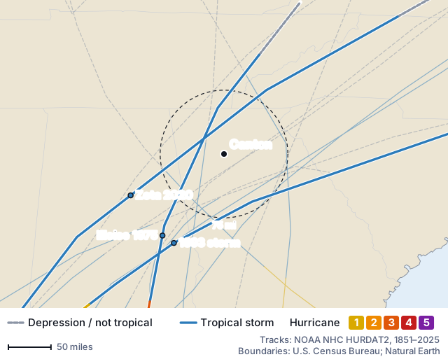
Of the 14 tracks on the map, 9 were moving northeast as they passed Canton, 2 north and 2 northwest. Zeta (2020), the strongest pass, was heading northeast; its centre passed 29 miles northwest of Canton. None made landfall within 75 miles of Canton; 10 of the 14 were hurricanes at their peak, none at their closest to the city. In the last 30 seasons (1996–2025), 2 came near Canton: 0.7 a decade, against 0.8 a decade from 1851 to 1995.
| Year | Storm | Closest | Strength when closest | Peak |
|---|---|---|---|---|
| 2024 | HeleneSep 27 | 69 mi | Tropical storm (51 mph) | Category 4 |
| 2020 | ZetaOct 29 | 29 mi | Tropical storm (58 mph) | Category 3 |
| 1975 | EloiseSep 23 | 29 mi | Tropical storm (53 mph) | Category 3 |
| 1932 | Unnamed 1932 stormOct 17 | 60 mi | Tropical storm (40 mph) | Tropical storm |
| 1915 | Unnamed 1915 stormSep 5 | 58 mi | Tropical storm (40 mph) | Category 2 |
| 1912 | Unnamed 1912 stormJun 14 | 46 mi | Tropical storm (40 mph) | Tropical storm |
| 1907 | Unnamed 1907 stormSep 23 | 17 mi | Tropical storm (40 mph) | Tropical storm |
| 1903 | Unnamed 1903 stormSep 15 | 68 mi | Tropical storm (40 mph) | Category 1 |
| 1902 | Unnamed 1902 stormOct 11 | 18 mi | Tropical storm (40 mph) | Category 2 |
| 1901 | Unnamed 1901 stormSep 28 | 70 mi | Tropical storm (40 mph) | Tropical storm |
| 1898 | Unnamed 1898 stormOct 3 | 64 mi | Tropical storm (39 mph) | Category 4 |
| 1893 | Unnamed 1893 stormOct 3 | 65 mi | Tropical storm (52 mph) | Category 4 |
| 1882 | Unnamed 1882 stormSep 10 | 73 mi | Tropical storm (46 mph) | Category 3 |
| 1859 | Unnamed 1859 stormSep 16 | 55 mi | Tropical storm (46 mph) | Category 1 |
Strength is the sustained wind on the track at the closest point, which is not the wind felt in Canton: a hurricane's worst winds sit within a few dozen miles of its centre, and inland cities are usually past that.
Check hail and hurricane history for any address
Tornadoes within 25 miles of Canton
By decade
- 2020s15
- 2010s13(1 EF3+)
- 2000s16(1 EF3+)
- 1990s18(6 EF3+)
- 1980s11
- 1970s17(3 EF3+)
- 1960s6(1 EF3+)
- 1950s8
| Date | Rating | Distance | Path | Killed / injured |
|---|---|---|---|---|
| Apr 3, 1974 | F4 | 14 mi | 17.7 mi | 6 / 30 |
| Mar 27, 1994 | F4 | 9 mi | 49 mi | 3 / 20 |
| Nov 22, 1992 | F4 | 4 mi | 20 mi | 0 / 46 |
| Mar 27, 1994 | F3 | 16 mi | 40 mi | 9 / 70 |
| Mar 27, 1994 | F3 | 25 mi | 44 mi | 3 / 45 |
| Mar 24, 1975 | F3 | 23 mi | 14.8 mi | 3 / 152 |
| Mar 15, 2008 | EF3 | 22 mi | 16.93 mi | 2 / 2 |
| Apr 27, 2011 | EF3 | 17 mi | 23.05 mi | 0 / 25 |
| Feb 21, 1993 | F3 | 22 mi | 8 mi | 0 / 3 |
| Mar 29, 1991 | F3 | 22 mi | 5 mi | 0 / 25 |
| Apr 2, 1970 | F3 | 17 mi | 6.5 mi | 0 / 0 |
| Mar 21, 1962 | F3 | 4 mi | 10 mi | 0 / 0 |
The strongest 12 of 104, by rating and then by deaths. Ratings before February 2007 are on the original Fujita scale.
Hail in Canton
The Storm Prediction Center has 124 hail reports within 10 miles of Canton since 1980, made on 98 separate days. Of these, 72 were 1 inch across or larger, and 9 reached 2 inches. The largest size, 2.75 inches (baseball size), was reported on 5 days, most recently May 20, 2008. The most recent report is from June 27, 2025. April has the most reports, 29.
Source: NOAA Storm Prediction Center severe weather reports, data through 2025.
Weather by month in Canton
The nearest NOAA station with 1991–2020 climate normals is Allatoona Dam 2, GA, 15 miles west of Canton at 975 feet. July is the warmest, with an average high of 88°F and low of 67°F; January is the coolest, at 51°F and 29°F. March is the wettest at 5.0 inches of precipitation on average and October the driest at 3.4 inches; the year adds up to 51.6 inches over 80 days with at least a tenth of an inch. June to November, the hurricane season months, bring 47% of the year's precipitation (24.2 of 51.6 inches); the other six months are wetter. September has brought the most of the 14 tropical systems that passed within 75 miles (8); a normal September there has highs of 82°F and 3.9 inches of precipitation. Highs reach 90°F on about 44 days a year, almost all from May to September. Lows fall below freezing on about 68 nights a year. That 51.6 inches is more than at 62 of the 108 Georgia stations used on this site (57%). Waleska, 10 miles northwest, has its own station (Jasper 1 NNW, GA): 58.7 inches a year, 7.1 more than here, and a July average high of 85°F against 88°F.
| Month | High °F | Low °F | Precip. in | Days ≥ 0.1" |
|---|---|---|---|---|
| Jan | 51 | 29 | 4.9 | 8 |
| Feb | 55 | 32 | 4.4 | 7 |
| Mar | 63 | 39 | 5.0 | 8 |
| Apr | 72 | 46 | 4.5 | 7 |
| May | 79 | 56 | 3.9 | 7 |
| Jun | 85 | 64 | 4.0 | 7 |
| Jul | 88 | 67 | 4.9 | 8 |
| Aug | 87 | 67 | 4.1 | 6 |
| Sep | 82 | 61 | 3.9 | 6 |
| Oct | 73 | 49 | 3.4 | 5 |
| Nov | 62 | 38 | 3.9 | 6 |
| Dec | 54 | 32 | 4.7 | 7 |
| Year | 71 | 48 | 51.6 | 80 |
Averages for 1991–2020 at Allatoona Dam 2, GA (975 ft), from NOAA NCEI U.S. Climate Normals. Normals describe the station; the farther a place is from it, and the bigger the difference in height, the more its weather can differ.
Floods, thunderstorm wind and lightning near Canton
Since 1996, the National Weather Service has logged 280 flood, rain, thunderstorm wind and lightning events that began within 10 miles of Canton: 238 thunderstorm wind reports, 27 lightning strikes, 10 flash floods and 5 floods. They killed 1 person and injured 9, and the NWS estimated $10.2 million in property and crop damage. The strongest thunderstorm gust on record here was 90 mph, on July 20, 2023. Of the 392 Georgia cities on this site with a flash flood on record, 189 have had fewer than Canton.
July 30, 2024: thunderstorm wind 6 miles from the centre of Canton — 1 killed, $1,000 damage.
NWS: “2 miles south of Millstone Way.”
February 16, 2001: thunderstorm wind 8 miles from the centre of Canton — 4 injured, $35,000 damage.
February 28, 2011: thunderstorm wind 9 miles from the centre of Canton — 1 injured, $500,000 damage.
Source: NOAA NCEI Storm Events Database, events whose starting point is on record, 1996 to June 30, 2026. Damage is the NWS estimate in the dollars of the year, not insured losses, and NWS notes that some reports are unverified.
Flood insurance claims, disaster declarations and FEMA risk ratings
Flood insurance policyholders in Canton's 2 ZIP codes have filed 21 claims with the National Flood Insurance Program since 1990, and were paid $767,000 for buildings and contents, in the dollars of each year. 43% of the claims carry the name of a storm or flood event; the rest have no event name. Of the 154 Georgia cities on this site with 10 or more claims, 44 have fewer than Canton.
Cherokee County, which includes Canton, has been named in 20 federal disaster or emergency declarations since 1977, 11 of them major disasters (by incident: 6 hurricanes, 4 severe storms, 2 biological emergencies, 2 tornadoes). The latest major disaster declaration was Tropical Storm Zeta, on January 12, 2021. FEMA's National Risk Index gives Cherokee County a Relatively Moderate rating for natural hazard risk overall; by hazard: Relatively High for tornadoes and lightning; Relatively Moderate for hail, inland flooding and strong wind; Relatively Low for heat waves; Very Low for hurricanes. It models the county's expected loss from all 18 hazards it covers at $78.3 million a year, the 7th highest of 159 Georgia counties; of the hazards above, the largest share, $46.4 million (59%), is from inland flooding.
Claims: FEMA, OpenFEMA Dataset FIMA NFIP Redacted Claims – v3, summed over ZIP codes; payments in the dollars of each year, not adjusted for inflation. Declarations: Disaster Declarations Summaries – v2, by county. Retrieved October 25, 2026. This product uses the Federal Emergency Management Agency's OpenFEMA API, but is not endorsed by FEMA. The Federal Government or FEMA cannot vouch for the data or analyses derived from these data after the data have been retrieved from the Agency's website(s).
Risk ratings: FEMA, National Risk Index county table, December 2025 (v1.20), retrieved October 26, 2026; ratings compare counties nationwide, are meant for planning and are no substitute for a local risk assessment. This product uses the Federal Emergency Management Agency's National Risk Index dataset API or downloadable datasets but is not endorsed by FEMA. The Federal Government or FEMA cannot vouch for the data or analyses derived from these data after the data have been retrieved from the Agency's website(s).
What counts as a pass, the distances and the sources: how this storm history is built.
Cities near Canton
- Woodstock, GA7 mi
- Waleska, GA10 mi
- Ball Ground, GA11 mi
- Roswell, GA14 mi
- Acworth, GA14 mi
- White, GA14 mi
- Kennesaw, GA15 mi
- Alpharetta, GA16 mi
- Jasper, GA17 mi
- Marietta, GA17 mi
- Rydal, GA17 mi
- Cartersville, GA19 mi
All Georgia cities →All hurricanes since 1851 →Compare Canton with another place →