Panama City Beach Hurricane History, Year by Year
Data: NOAA NHC HURDAT2 and NOAA SPC tornado and hail reports, through 2025 · Updated
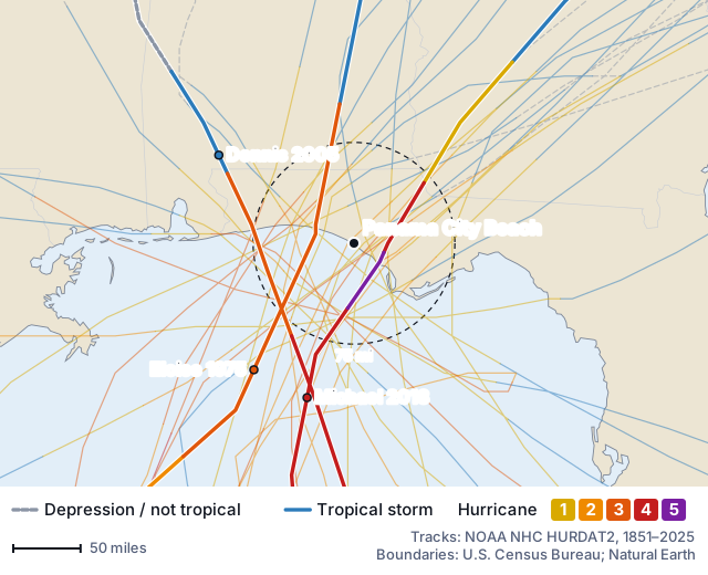
30 hurricanes passed within 75 miles of Panama City Beach at hurricane strength from 1851 to 2025: 22 of them within 50 miles and 11 within 25 miles. The most recent was Michael in 2018, 23 miles southeast of the city as a Category 5 hurricane; it came ashore 24 miles southeast of Panama City Beach. 22 of the 30 came ashore within 75 miles, 7 of them as major hurricanes (Category 3 or stronger at landfall).
- Hurricanes, 75 mi
- 30
- Came ashore nearby
- 22
- Most recent
- Michael 2018
- Longest gap
- 16 years
22 within 50 mi
7 as major
1956–1972
Every hurricane that passed within 75 miles of Panama City Beach
| Year | Storm | Date | Closest | Strength there | Panama City Beach on | Came ashore |
|---|---|---|---|---|---|---|
| 1851 | Unnamed 1851 storm | August 23 | 10 mi southeast | Category 3 (115 mph) | left side | 10 mi southeast, Category 3 |
| 1856 | Unnamed 1856 storm | August 31 | 3 mi northwest | Category 2 (102 mph) | centre within 5 mi | 5 mi west, Category 2 |
| 1867 | Unnamed 1867 storm | October 6 | 55 mi south | Category 1 (92 mph) | left side | — |
| 1877 | Unnamed 1877 storm | October 3 | 24 mi southeast | Category 3 (115 mph) | left side | 24 mi southeast, Category 3 |
| 1882 | Unnamed 1882 storm | September 10 | 53 mi northwest | Category 3 (112 mph) | right side | 60 mi west, Category 3 |
| 1886 | Unnamed 1886 storm | June 30 | 51 mi southeast | Category 2 (98 mph) | left side | 51 mi southeast, Category 2 |
| 1887 | Unnamed 1887 storm | July 27 | 48 mi northwest | Category 1 (84 mph) | right side | 48 mi west, Category 1 |
| 1894 | Unnamed 1894 storm | October 9 | 11 mi southeast | Category 3 (121 mph) | left side | 19 mi east, Category 3 |
| 1896 | Unnamed 1896 storm | July 7 | 40 mi northwest | Category 2 (96 mph) | right side | 43 mi west, Category 2 |
| 1903 | Unnamed 1903 storm | September 13 | 10 mi northeast | Category 1 (92 mph) | left side | 15 mi southeast, Category 1 |
| 1911 | Unnamed 1911 storm | August 11 | 63 mi southwest | Category 1 (81 mph) | right side | — |
| 1915 | Unnamed 1915 storm | September 4 | 25 mi east | Category 1 (81 mph) | left side | 29 mi southeast, Category 1 |
| 1917 | Unnamed 1917 storm | September 29 | 42 mi northwest | Category 2 (101 mph) | right side | 48 mi west, Category 3 |
| 1924 | Unnamed 1924 storm | September 15 | 45 mi southeast | Category 1 (86 mph) | left side | 46 mi southeast, Category 1 |
| 1926 | Unnamed 1926 storm | September 20 | 45 mi southwest | Category 3 (125 mph) | right side | — |
| 1929 | Unnamed 1929 storm | October 1 | 6 mi southeast | Category 1 (81 mph) | left side | 7 mi east, Category 1 |
| 1936 | Unnamed 1936 storm | July 31 | 40 mi southwest | Category 2 (102 mph) | right side | 48 mi west, Category 2 |
| 1939 | Unnamed 1939 storm | August 13 | 12 mi southwest | Category 1 (75 mph) | right side | 37 mi west, Category 1 |
| 1941 | Unnamed 1941 storm | October 7 | 73 mi east | Category 1 (84 mph) | left side | — |
| 1953 | Florence | September 26 | 24 mi west | Category 1 (92 mph) | right side | 24 mi west, Category 1 |
| 1956 | Flossy | September 25 | 27 mi northwest | Category 1 (78 mph) | right side | 37 mi west, Category 1 |
| 1972 | Agnes | June 19 | 15 mi southeast | Category 1 (75 mph) | left side | 15 mi southeast, Category 1 |
| 1975 | Eloise | September 23 | 29 mi west | Category 3 (127 mph) | right side | 32 mi northwest, Category 3 |
| 1985 | Elena | September 2 | 55 mi south | Category 3 (125 mph) | right side | — |
| 1985 | Kate | November 21 | 28 mi southeast | Category 2 (98 mph) | left side | 29 mi southeast, Category 2 |
| 1995 | Erin | August 3 | 48 mi southwest | Category 1 (87 mph) | right side | — |
| 1995 | Opal | October 4 | 74 mi west | Category 2 (106 mph) | right side | — |
| 1998 | Earl | September 3 | 10 mi southeast | Category 1 (81 mph) | left side | 10 mi southeast, Category 1 |
| 2005 | Dennis | July 10 | 67 mi west | Category 3 (127 mph) | right side | — |
| 2018 | Michael | October 10 | 23 mi southeast | Category 5 (159 mph) | left side | 24 mi southeast, Category 5 |
How often hurricanes reach Panama City Beach
The 30 hurricanes came in 28 different seasons. The median wait from one hurricane season to the next was 5 years; the longest, 16 years, ran from 1956 to 1972. 2 seasons brought two or more: 1985 (Elena and Kate) and 1995 (Erin and Opal). In the last 30 seasons (1996–2025) 3 passed within 75 miles of Panama City Beach at hurricane strength, against 6 in the 30 before (1966–1995) and 5.5 per 30 seasons from 1851 to 1965, when ships and coastal stations missed more storms.
The 1880s, 1910s, 1920s and 1990s each had the most hurricanes, 3. Tropical storms are the other 41 systems that passed within 75 miles below hurricane strength.
11 came in September, 7 came in October and 5 came in August. The earliest in the season was Agnes, on June 19; the latest, Kate, on November 21.
Strongest passes and the side of the storm Panama City Beach was on
15 of the 30 passed with Panama City Beach on their right-hand side, where wind and surge are usually strongest, and 14 with the city on the left; 1 passed within 5 miles of the city centre. The strongest right-side pass was Eloise (1975), a Category 3 hurricane 29 miles west of Panama City Beach. The strongest at their closest point: Michael (2018, Category 5, 159 mph, 23 miles away), Eloise (1975, Category 3, 127 mph, 29 miles away) and Dennis (2005, Category 3, 127 mph, 67 miles away).
Panama City Beach against nearby cities
Of the 6 cities compared here, Destin has the most hurricane passes within 75 miles (31) and Fort Walton Beach the fewest (28); Panama City Beach ranks 2nd. Port St Joe, 38 miles southeast, shares the fewest: 23 of its 30 hurricanes also passed within 75 miles of Panama City Beach at hurricane strength.
| City | Distance | Hurricanes, 75 mi | Within 50 mi | Shared with Panama City Beach | Strongest | Most recent |
|---|---|---|---|---|---|---|
| Panama City Beach, FL | — | 30 | 22 | — | Michael 2018, 159 mph | Michael 2018 |
| Panama City, FL | 12 mi east | 28 | 16 | 26 | Michael 2018, 158 mph | Michael 2018 |
| Port St Joe, FL | 38 mi southeast | 30 | 24 | 23 | Michael 2018, 160 mph | Michael 2018 |
| Destin, FL | 39 mi west | 31 | 21 | 28 | Michael 2018, 159 mph | Sally 2020 |
| Niceville, FL | 43 mi northwest | 28 | 17 | 25 | Michael 2018, 158 mph | Sally 2020 |
| Fort Walton Beach, FL | 50 mi west | 28 | 16 | 24 | Michael 2018, 159 mph | Sally 2020 |
- Panama City Beach's full storm record: all 71 tropical systems, tornadoes, hail and flood claims →
- Hurricane landfalls on the Gulf Coast, state by state →
How each figure on this page is counted: methodology.